
Reality Capture Connected to the Site: From Point Clouds to Decisions
September 24, 2026 · 9 min read
Executive summary
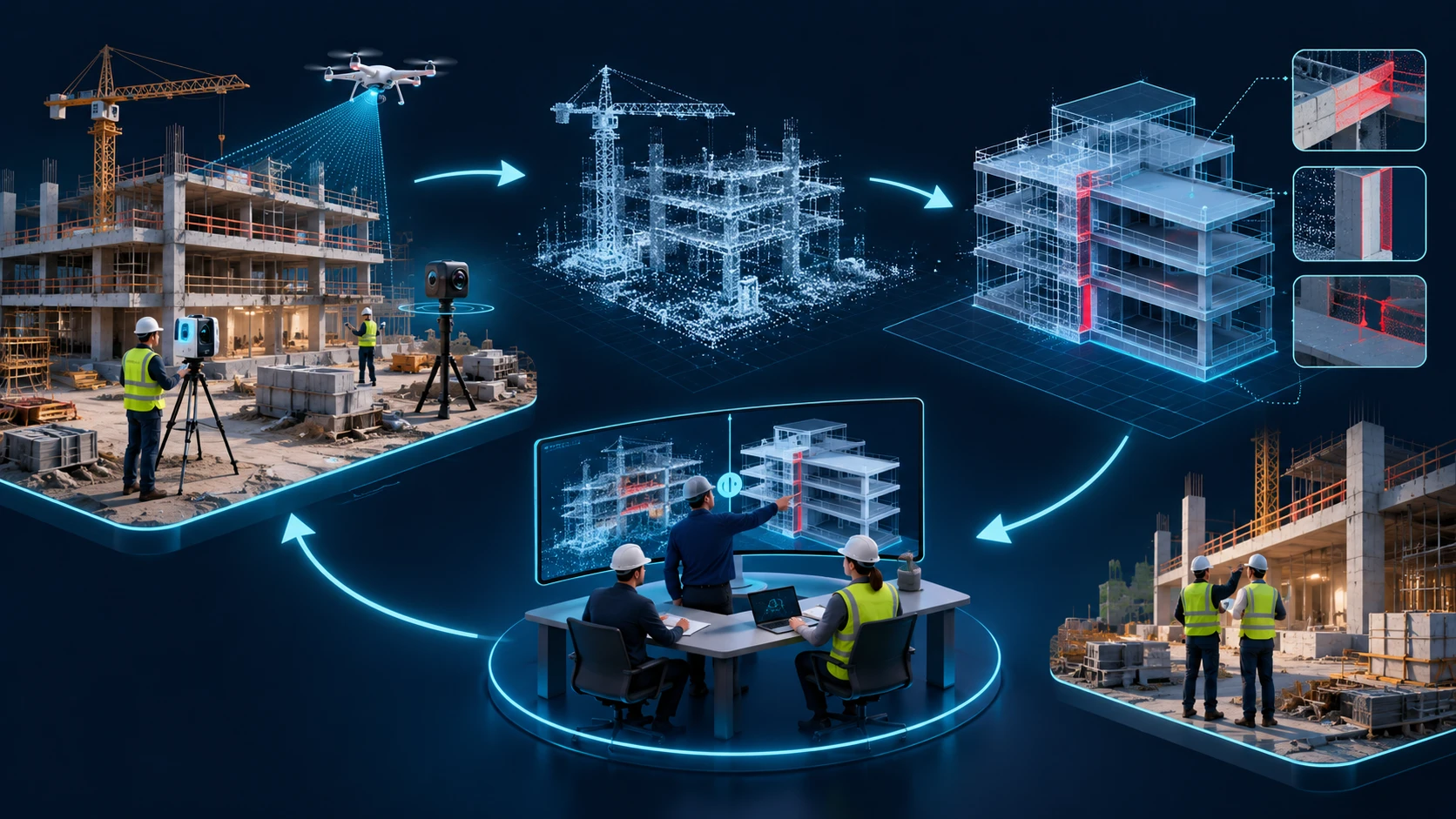
Reality capture — laser scanning, 360° photography, drone photogrammetry — has become routine on many sites. The shift now underway is not better sensors but a closed loop: capturing what was actually built, comparing it against the model, and feeding the difference back into decisions while there is still time to act. The bottleneck has moved from acquiring data to trusting and using it. As one contractor technologist put it at a July 2026 industry roundtable, "Scanning is easy. Uncertainty is expensive" [6]. The firms that gain an advantage will be those that specify how accurate the capture must be, keep it in open formats, and connect it to the model and the schedule — not those that simply own more scanners.
The real problem and what's changing
A model shows design intent; the site shows what happened. The distance between the two is where rework, disputes, and clashes with existing conditions come from. Bad or late project data was estimated to have cost the global construction industry $1.85 trillion in 2020 [2], and construction productivity grew only about 10% between 2000 and 2022, against roughly 90% in manufacturing [1]. Capturing reality is one way to close that information gap — but only if the captured data can be compared with the model in a way people trust.
It helps to separate three uses that are often blurred together:
- Existing conditions: documenting a building or site before design (the classic scan-to-BIM case for renovation and retrofit).
- Verification: checking that installed work matches the model — for example, that an installed rack or duct sits within tolerance of where it was coordinated.
- Progress and change tracking: repeated captures over time to see what was installed, what is missing, and what has moved.
The trend is from the first use toward the second and third: less "survey once, model once" and more "capture repeatedly, compare continuously."
Why now
Three things have converged. Capture is cheaper and faster: drones with RTK positioning now deliver sub-inch mapping accuracy for site documentation, earthwork volumes, and flatness or slope checks, and construction firms report that projects increasingly carry an explicit drone budget [7]. Visualization has improved: techniques such as 3D Gaussian splatting produce photorealistic site models from ordinary photos, which makes captures far easier for non-specialists to read [7]. AI is starting to handle the interpretation: recent research trains segmentation models on synthetic point clouds generated from BIM models, so that construction-site scans can be labeled by component (walls, slabs, columns) without hand-annotating real data. One 2026 study reports 70.89% overall accuracy and 53.14% mean IoU on real construction floors — promising, but a reminder that automated interpretation is not yet dependable enough to run unattended [5].
How it works and where it applies
The loop has a stable shape: capture (scanner, 360° camera, or drone, registered to site control) → registration and cleaning (aligning scans, removing noise and moving equipment) → exchange (open point-cloud formats such as E57, standardized as ASTM E2807 so scans move between manufacturers' software without loss [4]) → comparison (deviation analysis against the model, at a defined level of accuracy) → decision (accept, correct, or update the model) → record (the verified as-built becomes the new reference).
Concrete applications:
- Early detection of conflicts with existing conditions: field teams have reported progress-monitoring scans revealing power lines inside a code-restricted buffer zone before construction started, and a GNSS-based as-built capture flagging a telecom vault conflict roughly four months before construction would have reached that location [6].
- Installation verification for prefabricated work: confirming that structure, sleeves, and supports sit where the fabricated assemblies assume they do, before a rack or spool arrives.
- Progress monitoring: comparing repeated 360° or drone captures with the model and schedule to see what is installed, what is missing, and where issues may be forming [8].
- Renovation and retrofit: modeling existing MEP and structure from scans so new routing is coordinated against what is really there, not against outdated drawings.
Business and team impact
The value is less about the scan itself than about earlier, cheaper corrections: a discrepancy found while work is still accessible costs far less than one discovered after finishes are installed. For a BIM or VDC team, the role shifts from producing models to auditing reality against models — someone has to decide what accuracy is needed, check deviations, and update the reference.
It also changes how firms document their work. A dated, verified as-built capture is objective evidence of conditions at a moment in time, which is useful in disputes and for handover — provided the capture is accurate, registered, and traceable. That connects reality capture to the same governance themes as the rest of this series: data ownership, traceability, and who is accountable for what the model says.
Barriers, risks, and maturity level
Accuracy is underspecified. Many scan-to-BIM disagreements come from vague expectations ("as-built accurate"). The USIBD Level of Accuracy (LOA) specification exists to state accuracy as a tolerance; its current version, 3.1, published in January 2025, introduced a practical way to convert between tolerance and standard deviation [3]. Even so, academic work has noted that LOA defines accuracy levels without prescribing a single standardized method to assess a model against a point cloud, and that a deviation analysis depends on the mathematical model used, the density of the point cloud, and the order of comparison [9]. Two teams can therefore report different deviations from the same data unless the method is agreed in advance.
Data volume and practicality. One field practitioner described a single exported LAS file of 350 GB containing 25 billion points, beyond what most software can open; workflows depend on decimation that preserves precision only where it matters [6]. Site conditions also limit capture: vibration from concrete pours, standing water, and equipment obstructing scanner positions all degrade or prevent scanning [6]. And, as practitioners note, "the hardest part is just knowing what to do with this data" [7].
Maturity is uneven: laser scanning for existing conditions is mature and widely specified; drone and 360° capture for progress tracking is established but inconsistent in how results are used; automated, AI-driven comparison and segmentation is emerging — active research with promising but not yet production-grade accuracy [5]. Vendor sources project that combining AI, reality capture, and model-based workflows will improve progress tracking and reduce rework [8]; treat these as directional expectations rather than measured results.
How to prepare
- Specify accuracy explicitly. State the required LOA (or tolerance) per element type, and agree how deviation will be measured and reported before scanning starts [3][9].
- Use open formats for exchange and archive. Deliver point clouds in E57 alongside any proprietary formats so the data outlives any one software vendor [4].
- Capture for a decision, not for its own sake. Choose scan frequency and coverage around specific verification points — sleeves, main routes, equipment pads — rather than scanning everything [6].
- Keep captures traceable. Record date, sensor, registration quality, and control used, so a later dispute can rely on the data.
- Define who acts on deviations. Assign an owner and a threshold for what triggers a model update or a field correction; otherwise scans become archives nobody uses [7].
Future outlook and conclusion
The likely direction is more frequent, lighter capture (360° and drone) compared automatically against the model, with high-accuracy laser scanning reserved for the points where tolerance really matters. Semantic AI will keep improving, but the near-term pattern is assisted review — software flags candidate deviations, a person confirms them [5]. Whether photorealistic representations such as Gaussian splats become accepted for measurement, and not just visualization, remains an open question that depends on how well they preserve verifiable accuracy.
The strategic point: reality capture does not make a model true; it makes disagreement measurable. A firm that treats it as a filing exercise collects large files. A firm that agrees on accuracy, keeps data open, and connects deviations to decisions gets something more valuable — an as-built record it can defend.
Frequently asked questions
Is scan-to-BIM the same as reality capture? No. Scan-to-BIM converts captured data into a model, mostly for existing conditions. Reality capture also covers verification and progress tracking, where the point cloud is compared with an existing model rather than used to create one.
Which is better: laser scanning, 360° photos, or drones? It depends on the accuracy required and the area covered. Laser scanning suits high-accuracy verification; 360° captures suit frequent progress documentation; drones suit large outdoor areas, earthwork, and roofs. Many projects combine them.
Can AI automatically build the model from a scan? Partly. Research is advancing, but published results on real construction sites still show meaningful error rates and confusion between geometrically similar components [5]. Human review remains necessary.
Sources and references
[1] Mischke, J.; Stokvis, K.; Vermeltfoort, K.; Biemans, B. "Delivering on construction productivity is no longer optional." McKinsey & Company, August 9, 2024.
[2] Autodesk & FMI. "Harnessing the Data Advantage in Construction." 2021.
[3] USIBD (U.S. Institute of Building Documentation). Level of Accuracy (LOA) Specification, Version 3.1, released January 2025.
[4] ASTM International. ASTM E2807 — Standard Specification for 3D Imaging Data Exchange, Version 1.0 (E57 file format).
[5] Zou, Y.; Liang, T.; Nabi, J. S. R. U.; Xu, Z.; Zhou, L.; Xiong, B. "A BIM-Guided Virtual-to-Real Framework for Component-Level Semantic Segmentation of Construction Site Point Clouds." Sensors, 26(1), 308, 2026. https://doi.org/10.3390/s26010308
[6] Geo Week News. "Reality Capture in Active Construction Environments: Insights from the Field," July 1, 2026 (interviews with practitioners at Brasfield & Gorrie and Envision Construction).
[7] Wall, D. "Drone reality capture ramps up to augment construction site workflows." Daily Commercial News (ConstructConnect Canada), February 19, 2026.
[8] Autodesk. "2026 State of Design & Make: AI Pulse" and Digital Builder, "2026 Construction Trends: 25+ Experts Share Insights" (vendor perspective; directional, not measured results).
[9] "Scan-to-BIM Output Validation: Towards a Standardized Geometric Quality Assessment of Building Information Models Based on Point Clouds." ISPRS Archives, XLII-2/W8, 2017.
Traceability note: market-size estimates for reality capture vary by more than a factor of two across commercial research reports, depending on scope, so none are used here. Two frequently repeated statistics attributed to Dodge Construction Network (fewer unplanned changes, reduced errors and rework from reality capture) could not be confirmed in a primary source and were left out.